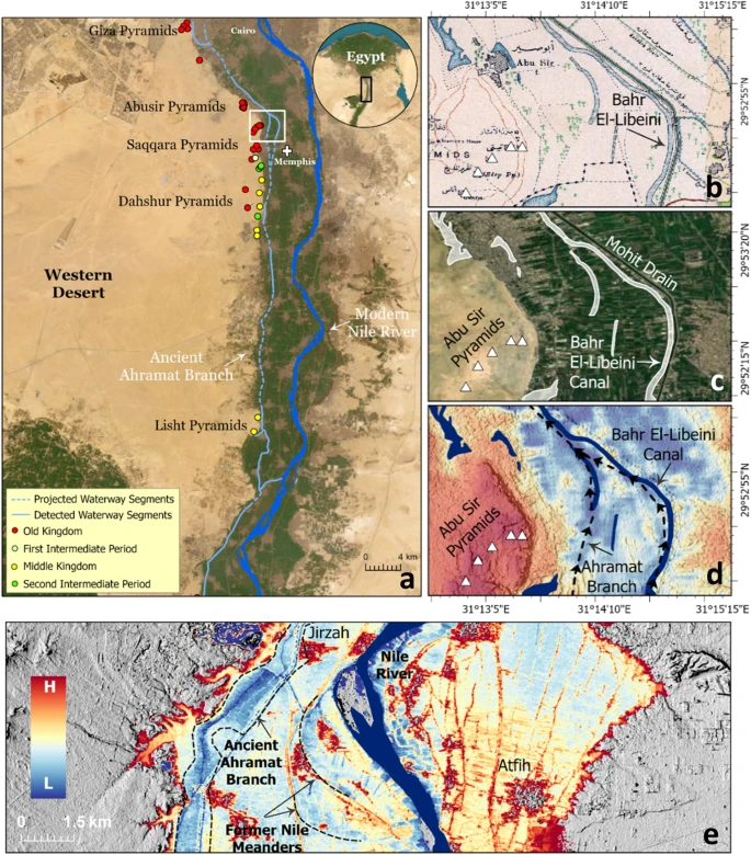
Researchers from the University of North Carolina Wilmington using radar satellite imagery found a major extinct branch of the Nile. The extinct branch of the river flowed through the foothills of the Western Desert Plateau, where a large cluster of the Pyramids stand.
The Nile River played a fundamental role in the rapid growth and expansion of the Egyptian civilization. It has provided sustenance and functioned as the main waterway for the transportation of goods and building materials. This led to the construction of most of the key cities and monuments near the banks of the Nile and its peripheral branches. However, over 30 pyramids in Egypt are located in an extraordinarily barren strip of the desert, far from the banks of the Nile River.
The latest research published by a team of researchers from the University of North Carolina Wilmington sheds light on the reason for this unusual occurrence. The researchers found a large extinct branch of the Nile, which was 64 kilometres (40 miles) long and over 600 metres wide, using radar satellite imagery combined with geophysical data and deep soil coring. The study investigated the subsurface structure and sedimentology in the Nile Valley next to these pyramids. They named it ‘Ahramat Branch’, which means Pyramids Branch in Arabic.
The discovery of this extinct waterway explains the large cluster of pyramids in the region and provides an answer to the question of how materials were transported to build the Giza complex and other pyramids that dot the Western Desert Plateau. The study also suggests that the extinct branch was the main mode of commute for the workmen.
The study cites that over time the main course of the Nile River laterally migrated, and its peripheral branches silted up, leaving behind many ancient Egyptian sites distant from the present-day river course. The Ahramat Branch moved steadily eastward. The traces of this branch are found in historical maps of the area from 1911. The Dahshur Lake is probably the last existing evidence of the tributary.

